Welcome back, my aspiring OSINT investigators!
The Internet is the largest repository of data in the history of the world! Learn how and where to access it to bring its power and intelligence into your hands!
Open Source Intelligence (OSINT)
Open source Intelligence (OSINT) is useful and applicable to so many industries, such as;
Pentesting and hacking;
Private Investigations;
Economic analysis;
Investigative journalism;
Corporate Investigations, and many others.
In this series on OSINT, I attempt to cover a multitude of techniques that can be used by any or all of these industries.
Source #1: Maritime Traffic Tracking
There are a number of sites that track maritime traffic, but marinetraffic.com is my favorite. This site tracks nearly every ship by either;
AIS -Automatic Identification System. Has a range of 30 miles;
Satellite – tracks ships over any distance using IMMARSAT;
Mobile Networks – tracks ships in inland waters via mobile phone networks
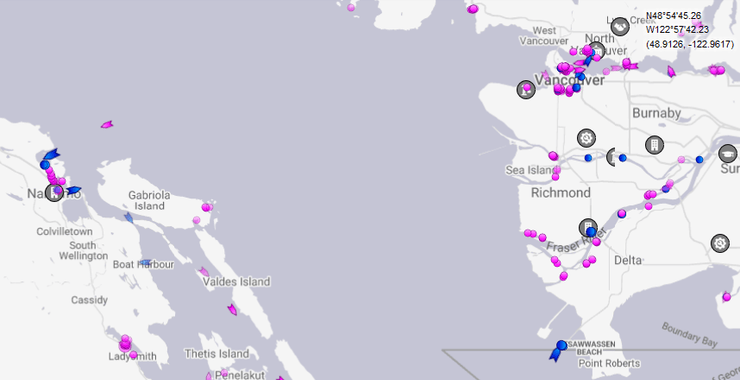
When you open marinetraffic.com you will see a map similar to the map below of the Seattle, WA in the US and Vancouver, BC in Canada area.

You can select what type of vessels you want to track by clicking in Vessel Filters on the left hand menu.

Step #2 Filtering by Vessel Type
As noted above, OSINT analysis can be used in many types of investigations. Let’s assume for now that you are interested in commercial or economic analysis. In this type of analysis, you might be seeking answer to questions such as ;
1. What is a present state of a local or regional economy
2. What is the present state of local or regional business
3. How much oil is a region using (using a good indication of economic health or maybe global climate change awareness)
4. and many other similar questions.
OSINT analysis will likely help you with any of those questions.
To begin, let’s assume you are trying to ascertain the present state of the local economy. Shipping data will be a key indicator of an economy’s health. A prosperous economy is likely to see more cargo vessels and tankers than a weak economy. To determine this type of local economic activity, we can create a filter of just vessels that carry cargo or are tankers. When we do that for the Vancouver, BC area, we can see the following map of the area. Note the many cargo vessels in green and a few tankers in red.

We can click on one of those vessels and get more information. As you can see below, this vessel is the Indian Goodwill traveling from Dafeng China on March 22 and arriving to Vancouver Anchorage on April 7.

Next, we can click on the Past Track button and see its route over the last 24 hours (longer periods of time are available with a paid subscription).

Apparently, the Indian Goodwill has been anchored in the bay for the last 24 hours and traveling in circles probably waiting for its turn in the port.
Step #3 More Vessel Filters
On the other hand, you can use OSINT for private investigations. Maybe you are tracking a fugitive. You know they have a boat in the Vancouver area, but don’t know where they have gone.
If you know the name of the vessel, you can enter into the “Search Marine Traffic” window and find the exact location of the vehicle.

If you didn’t know the name of the vehicle and only suspected they were in the Vancouver/Vancouver island area, the first step might be to filter for just Passenger vessels or Pleasure craft or both. Here we have filtered for both. Now we can see only the smaller vessels in the area.

When we hover over any of these vessels, it will reveal the name and provide a photo on the vessel, if available. Here we found the East West Dreams positioned near Galiano Island. As you can see, the position data was very recent, updated just 37 minutes ago (satellite data is nearly real-time).

When click on the Vessel Details just below the vessel picture, we can get even more information about the vessel including its precise position, its speed, data source, and current port.
On this same screen, even more data is available. We can see that our potential fugitive left Vancouver 4 hours ago.
Summary
Open source Intelligence can play a key role in many types of investigations. When sea vessel information is required, a web site such a marinetraffic.com can be essential to tracking traffic by sea. This type of data can be crucial in commercial or economic analysis to determine conditions in a local economy or a specific company. In addition, this information can be used to track a specific person/vessel as they move along the waterways.


